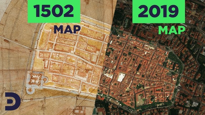
Leonardo da Vinci came in 1502 to serve as a military engineer for Cesare Borgia at Imola, Italy. His mission was to acquaint Borgia with the location, but instead of creating a map in the period manner, complete with artistic embellishments and a side perspective of the city, Leonardo created a contemporary, astonishingly realistic map of Imola including a bird's-eye view. The outcome is very comparable to modern satellite photos of the city's historic core, proving that the Renaissance genius's remarkable symbolic imagination allowed him to live many centuries ahead of his time.
Leonardo described Imola using the concept of an ichnographic plane, which was popularized by the Roman engineer Vitruvius and allowed the observer to see oneself immediately above a structure to have a clear perspective of what he saw. Nevertheless, Leonardo used his technical expertise to accurately map the city and describe just one structure.
Leonardo marked street corners in reference to a fixed point, the north, and counted degrees using a disk with a pointer, according to the map designs that have survived. It is believed that he used a compass to note the alignment of the city walls.
To calculate the scale, he would have measured the separations between these angles—likely on foot or with the use of a wheel odometer. Centuries before anybody could check the correctness of his design, he was able to compile all the angles and distances throughout the city.
Leonardo's map is accurate, but it also has artistic aspects that may have been found via earlier investigation. Despite these aesthetic compromises, the map represents more than just a city; it signifies the change from a mythical and subjective geography to a straightforward and factual one. It was actually a highly sophisticated map for the period.
